Mills County
Bethlehem City, Mills County, Iowa
Location
Bethlehem was established on the banks of the Missouri River in 1846 by Latter-Day Saints (1). Its location was on the east side of the Missouri River opposite Plattsmouth, Nebraska. The 1868 Iowa & Missouri State Line Railroad Map shows it in Section 26, Plattville Township, Mills County, Iowa (2).

History
The town was first called Bethlehem. It was washed away by a flooding Missouri River sometime after 1868. It was rebuilt but farther back from the river and was then called Sharpsburg. Sharpsburg was eventually renamed Junction City and finally East Plattsmouth (3).
The Mormons had three main places from which they ferried across the Missouri River into Nebraska where they finally set up their Winter Quarters of 1846-1847. Two of these places correspond quite closely with where the South Omaha and the Mormon Pioneer Memorial bridges are today. The third site is some 20 miles to the south, near present Plattsmouth, Nebraska (4).
Joseph L. Sharpe was one of the early citizens of Bethlehem. He ran a ferry at this location prior to 1854, and he received an official license from Mills County, Iowa on May 1, 1854, to reestablish a ferry. The county granted him two miles of shoreline on the Iowa side to set up his business. A Mills County judge allowed him to charge the following rates:
For wagon and two horses: $1.00; for wagon and four horses: $1.50; for footman: $.10; for horseman: $.50; for sheep per head: $.05; for cattle per head: $.10.
The license decreed, “The time for ferrying is between sunrise and sundown, at all times when the river is within its banks and in boating order” (5).
The South Mormon Ferry was built in about 1850. Its purpose was to get the Latter-Day Saint families traveling to Utah away from the heavy California God Rush traffic by traveling on the south side of the Platte River. By the spring of 1850, warehouses were built in Bethlehem and emigrating families were instructed to store their supplies and pick them up as they prepared to go west.

When Bethlehem was platted in a new location further from the river, the surveyor, W. Sharp, renamed the town Sharpsburg (6). The name Junction City may have come from the town's location at the terminus of a lesser railroad, the Burlington & Missouri River Railroad. By 1879, the name had changed to East Plattsmouth, the town being directly east across the Missouri River from Plattsmouth, Nebraska and near the mouth of the Platte River (7).
The post office history gives some insight as to the dates of the different names of the town. “Established as Sharpsburgh March 10, 1860, David W. Palmer; closed January 2, 1868; reopened January 11, 1867, William J. Gates; discontinued April 2, 1868; reopened as Junction City March 2, 1870, Leander Cooley; closed November 25, 1872; reopened as East Plattsmouth February 5, 1877, William R. Eledge; discontinued May 16, 1881” (8).
Probably because of the ferry, Bethlehem held a place of relative importance among the towns of the Middle Missouri Valley. The Frontier Guardian newspaper used it as a reference point to give the location of another town where a wagon train was about to begin its trek to the Salt Lake Valley (9). David Dixon was The Frontier Guardian agent in 1851 (10).
Latter-Day Saints referred to Bethlehem in their journals and autobiographies on occasion as a place where their company either met or stopped on the way to the Salt Lake City.
“I [Edson Whipple] was called to assist him [Wilford Woodruff] in visiting the saints and help gather them. I had been laboring in Maryland, where I baptized several and organized a branch of 16 members. Visiting Bro. Woodruff in Boston, I was requested to cross the plains in his company in the summer of 1850. I met him at Bethlehem, at the crossing of the Missouri river, where his company was organized with captains of tens, fifties, and hundreds. I was appointed captain of fifty” (11).
“After a long illness, he [Russell King Homer] moved west again to a small village called Bethlehem on the east bank of the Missouri River and went into the mercantile business” (12).
“The Clemens family were part of the company formed by Orson Hyde two miles from the ferry above Bethlehem with Warren Foote as captain” (13).
“Sophia Goodridge and others started from Kanesville at 1:00 p.m. for Bethlehem. Rode ten miles and camped at Margarets Creek, a very beautiful shady spot. We heard the wolves howl in the night for the first time. Our horses were frightened. 8th Saturday. Traveled seven miles, camped three miles from Bethlehem. We enjoyed ourselves very much at the last two places we camped. Had two violins in our ten… 14th. Went three miles, camped at Bethlehem, had a pleasant time, some music and dancing” (14).
“Subsequently about forty small settlements were founded in the same county, most of which flourished until the general removal of the Saints to Great Salt Lake Valley in 1852. Among these may be mentioned . . . Bethlehem” (15).
Cemetery
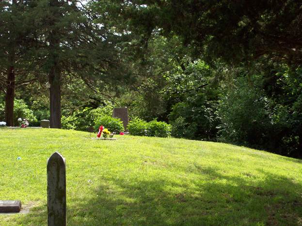
If the settlement had a cemetery, it would have been washed away when the Missouri River flooded.
Possible Burials
| Name | Birth Date | Death Date |
| Hyrum A. Pettigrew | 29 Oct 1846 | 21 Nov 1846 |
| Franklin O’Neill | 1843 | 1850 |
| Rhoda Rowantha Josephine Sharp | 6 Oct 1853 | 7 Oct 1854 |
Bibliography
- Iowa Historical Company, History of Mills County, Iowa: containing a history of the county, its cities, towns, etc., a biographical directory of many of its leading citizens, war record of its volunteers in the late rebellion, general and local statistics ... history of Iowa and the Northwest, map of Mills County ... etc. (Des Moines, Iowa: State Historical Company, 1881), p. 590.
- G. W. & C. B. Colton & Co., Iowa & Missouri State Line Railroad Map, 1868. Library of Congress Geography and Map Division, Washington, D. C.
- Mott, Abandoned Towns, Villages and Post Offices of Iowa, 91; Federal Writers' Project of the Works Progress Administration for the State of Iowa, Southwestern Iowa Guide: Geology—Points of Interest--History (New York: Viking Press, 1938), p. 116.
- Ibid.
- Heubach, New Railroad Map of the United States and the Dominion of Canada; Iowa Historical Company, History of Mills County, Iowa, p. 590.
- Iowa Historical Company, History of Mills County, Iowa: containing a history of the county, its cities, towns, etc., a biographical directory of many of its leading citizens, war record of its volunteers in the late rebellion, general and local statistics ... history of Iowa and the Northwest, map of Mills County ... etc. (Des Moines, Iowa: State Historical Company, 1881), p. 590.
- Mott, Abandoned Towns, Villages and Post Offices of Iowa, 91; Emil Heubach, New Railroad Map of the United States and the Dominion of Canada, Showing the Chicago, Rock Island and Pacific R.R.: The Great Overland Route and Short Line to the West and South-west (Chicago, 1879).
- Guy Reed Ramsey, Postmarked Iowa: a list of discontinued and renamed post offices. Crete, Nebraska: J-B Publishing Company, 1976, p. 311.
- Charles H. Babbitt, Early Days at Council Bluffs, 1916, p. 86.
- Orson Hyde, ed., Frontier Guardian, Vol. 3, No. 5, April 4, 1851.
- Andrew Jenson, LDS Biographical Encyclopedia: a compilation of biographical sketches of prominent men and women in The Church of Jesus Christ of Latter-day Saints (Salt Lake City: Western Epics, 1971), 3:560-1.
- Kate B. Carter, Our Pioneer Heritage (Salt Lake City: Daughters of Utah Pioneers, 1958-1977), 2:46-47.
- Kate B. Carter, Our Pioneer Heritage (Salt Lake City: Daughters of Utah Pioneers, 1958-1977), 2:291.
- Kate B. Carter, Our Pioneer Heritage (Salt Lake City: Daughters of Utah Pioneers, 1958-1977), 15:254.
- Kate B. Carter, Our Pioneer Heritage (Salt Lake City: Daughters of Utah Pioneers, 1958-1977), 17:114.
View list of community residents
Browning’s Camp, Mills County, Iowa
Location
Jonathan Browning set up his gunsmithing shop south of Point aux Poules, near where Mosquito creek entered the Missouri River. Browning started advertising April 4, 1849, with this message: “GUNSMITHING: The subscriber is prepared to manufacture, to order, improved Fire-arms, viz: revolving rifles and pistols; also slide guns, from 5 to 25 shooters. All on an improved plan, and he thinks not equaled this far East. (Farther west they might be). The emigrating and sporting community are invited to call and examine Browning’s improved firearms before purchasing elsewhere. Shop eight miles south of Kanesville on Musquito [sic] Creek, half a mile south of Trading Point. Jonathan Browning (1).”
The 1851 Pottawattamie County Survey Maps with Illustrations shows the location of Browning’s Camp on Mosquito Creek.


History
Latter-day Saints were the founders of this settlement. In the Frontier Guardian, the settlement is referred to simply as “Brownings” (2). The settlement was likely named after Jonathan Browning, a resident of the community. It was also known as Big Bend and now located in Mills County. The residents belonged to the Big Bend Branch of the Church of Latter-day Saints.
Jonathan Browning probably arrived at the site where he established Browning’s Camp in 1846 or 1847. Although no record explicitly states when Browning arrived at the site of Browning’s Camp, one record says that Browning traveled “to Council Bluffs” with Orson Hyde, and yet another says that Orson Hyde presided over the Church from 1847-1852. So, Browning was in the area by 1847, if not actually at the site of Browning’s Camp (3). Jonathan Browning was the Frontier Guardian agent in Browning’s Camp (4).
Apparently, Browning’s Camp was a large community. Another option is that its proximity to Trader’s Point made possible the recording of people from both settlements in the same day when Luke Johnson took down the census of 1850. Many of the people who were recorded on the census on the first day of its taking traveled to the Salt Lake Valley together (5). These facts indicate that the ten families who were living near each other in 1850 and traveled together in 1852 did, in fact, live in the same community, Browning’s Camp.
A number of skilled craftsmen and workers lived in Browning’s Camp. Unlike men in other communities, not a single one in Browning’s Camp has “None” written under the heading, “Profession, Occupation, or Trade of each Male Person over 15 years of age.” Browning’s Camp consisted of 15 laborers, 2 farmers, 3 gunsmiths (Jonathan Browning and two sons), 2 coopers, 1 carpenter, 1 miller, 1 mill wright, 1 machinist, and 1 blacksmith. If each of these plied their trade, being, as they were, so close to Trader’s Point, they could have been quite prosperous (6).
There is not a known cemetery at Browning’s Camp. There was a cemetery at Trader’s Point and one at Kanesville. Several people died while living at Browning’s Camp or near it.
| Name | Birth Date | Death Date |
| William James Morgan | 1806 | 1849 |
| Sarah “Sally” Canfield Sabin | 17 Jan 1825 | 6 Jan 1849 (7) |
| John William Melville | 21 Jun 1849 | 24 Feb 1850 |
| Lyman Lafayette Corey | 18 Jan 1809 | 25 Mar 1850 |
| Richard Galliher | 2 Mar 1845 | Aug 1850 |
| John Bamford | 21 Sep 1788 | 5 Sep 1850 |
| Maria Golding Bradbury | 6 Jun 1795 | 6 Oct 1850 |
| Thomas Richmond | 21 Dec 1809 | 20 Dec 1850 |
| Ann Parsons Lovell | Sep 1808 | 4 Dec 1851 |
Bibliography
- Hyde, Orson, Ed., “Gunsmithing.” Frontier Guardian [Kanesville, Iowa], April 4, 1849.
- Hyde, Orson, Ed., Frontier Guardian [Kanesville, Iowa], April 4, 1851.
- Microfilm 920 no. 89, “The Late Jonathan Browning” (July 30, 1879), L. Tom Perry Special Collections, Harold B. Lee Library, Brigham Young University, Provo, Utah.
- Hyde, Orson, Editor. “Agents for the Guardian in this County.” Frontier Guardian [Kanesville, Iowa], October 2, 1850.
- United States Federal Census, 1850, 1-5, 87, 153-154. Holmes, Old Council Bluff(s): Mormon Developments, 1846-1853, in the Missouri and Platte River Valleys of SW Iowa & E Nebraska, Karen Larsen, ed., 10.
- Gail Geo. Holmes, Old Council Bluff(s): Mormon Developments, 1846-1853, in the Missouri and Platte River Valleys of SW Iowa & E Nebraska, Karen Larsen, ed. (Omaha: Omaha LDS Institute of Religion, 2000), 36-37.
- Orson Hyde, ed., Frontier Guardian, 21 February 1849.
View list of Community Residents
California City, Mills County, Iowa
Location
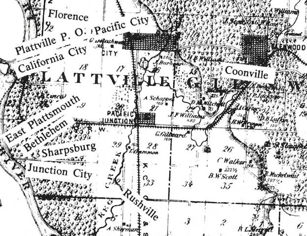
California City was a Missouri River town and eight miles south of Trader's Point (1). It is located in Platteville Township (2).History
Some sources mention that California City was also called Florence (8). However, the Plewe map shows them as separate but very close in proximity. Florence, Mills County, Iowa should not be confused with the Florence, Nebraska, settlement.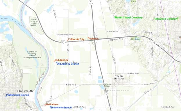
Considering the fact that the first settlers were en route to California, the name was probably an enthusiastic emblem of the founders' desire to reach their final destination.
The town was surveyed on December 18, 1849. Explanations were recorded on the plat map that was drawn. Main Street and Broad Way were the main roads. Each was 80 feet wide. Other streets were each 60 feet wide. Alleys were each 16 feet wide. The Church Square, Court Square, and College Square were 336 feet. Each lot was 56 feet wide and 168 feet when not bounded by an alley. Each lot not bounded by an alley was 160 feet long (3).
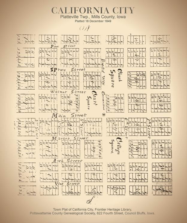
The Proprietors of California City listed on the document were Julius Barnes, Andrew J. Stewart, Ambrose Clark, Waldo Tozier, George Clark, and Elijah Haws. Each was proprietor of specific blocks and lots of the town (4).
One account says that the settlement was started by a company of California bound emigrants from Illinois who reached this point in the late fall of 1849. They decided to stay the winter there (5). A church and school were started and flourished several years (6). The settlers of California City attended the Rushville Branch of the Church of Jesus Christ of Latter-day Saints. The map shows the settlement of Rushville.
Many little settlements were started in Mills County in the early years. Many were replaced by others or deserted. Among the first settlements which were gone were those along the Missouri River and when the Missouri River flooded they were washed away and they were not rebuilt (7). California City was one of those settlements.
Cemetery
Martin Chapel Cemetery, which is located in Pacific City, was associated with this settlement.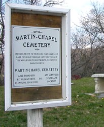
The earliest burials were not marked but may have been along the slope in this area.
Possible Deaths & Burials
| Name | Birth Date | Death Date |
| Samuel Sylvester Stewart | 18 Aug 1848 | 18 Aug 1848 |
| Silvia Caroline Stewart | 6 Apr 1850 | 6 Apr 1850 |
| Emaline Tozier | 1848 | Abt 1851 |
| Clarissa Clark | 1844 | 1851 |
| Laura Augusta Longworthy Barnes | 1825 | 23 Jun 1852 |
| Daniel Clark | 16 Jan 1793 | 5 Aug 1857 |
| Orpah Hale Barnes Clark | 17 Nov 1793 | 15 May 1858 |
| George Washington Clark | 29 Jan 1823 | 30 Aug 1880 |
| Sarah Ann Coulson Clark | 12 Dec 1825 | 7 Jul 1900 |
| Cordelia Clark Martin Henton | 23 Oct 1825 | 11 Mar 1904 |
| James Hale Clark | 27 May 1828 | 1 May 1904 |
| Julius Barnes | 15 Jan 1815 | 15 Mar 1906 |
Bibliography
1. Works Progress Administration, Southwestern Iowa Guide: Geology--Points of Interest--History (1936), 116.2. Allen Wortman, Ghost Towns of Mills County, Iowa, Wortman, 1975.
3. Town Plat of California City, Frontier Heritage Library, Pottawattamie County Genealogical Society, 622 Fourth Street, Council Bluffs, Iowa.
4. Ibid.
5. "Latter-day Saint Settlements in the Middle Missouri Valley : 1846-1852," (map), in part from Government Land Office plats of 1855-57.
6. Luke William Gallup, "Biography and Journals: May 1842-March 1890," microfilm 920, no. 33, L. Tom Perry Special Collections, Harold B. Lee Library, Brigham Young University, Provo, Utah.
7. Works Progress Administration, Southwestern Iowa Guide: Geology--Points of Interest--History (1936), 116.
View list of community residents
Coonville, Mills County, Iowa
Location
The Coonville settlement was only about 5 to 6 miles from Bethlehem. It was also about 10 to 12 miles from where Keg Creek emptied into the Missouri River, south of Bethlehem.
History
Charles H. Babbitt, in his book Early Days at Council Bluffs recorded: “Probably more than half of the people (from Winter Quarters) went with the departing train to Salt Lake City; and a majority of those remaining removed to Kanesville, while others settled at various places within the Pottawattamie country, notably at Carterville, Macedonia, Springville, in Pottawattamie County, and Cutler's Camp, Coonville (now Glenwood), and Bethlehem, in what is now Mills County, the last-mentioned place having been swept away by the Missouri river long ago. It was opposite the mouth of the Platte River” (1).In one of the first groups arriving from Nauvoo was a man by the name of Lebbeus Thaddeus Coons, a medical doctor who attended the health needs of the leaders and many others requiring his services along the way. He was among the groups who traveled up and down the Missouri Valley in what is now Harrison, Pottawattamie, and Mills Counties looking for suitable sites to accommodate small settlements.
Silas Hillman wrote, “L.T. Coons and I, with my brother Ira, and some others, went north as far as Harris Grove to hunt us a claim of land. We looked around the country and then returned home” (2). The first settlement was called Rushville. Rushville died almost as soon as it was born. It was found that the area was in the flood plain.
In February 1848, the Rushville settlers went about 10 miles up Keg Creek into the bluffs to secure timber, soil and water. They made claims, built houses and moved into them. They split rails and fenced their fields.

The town was laid out with a central public block running parallel to the four quadrants and a small block laid out a short distance from the square. A grist and sawmill were built on the creek, about three fourths of a mile from their claims. The owners advertised the following in the Frontier Guardian:
KEG CREEK MILLS FOR SALE.
THE subscribers, wishing to remove in the Spring to the Valley of the Great Salt Lake, offer for sale their new SAW AND FLOURING MILLS, providing they can sell within one month, otherwise they do not wish to sell at present, for that would break into the arrangements for next Fall. The mills and the seat are decidedly the best in this western country. Call and examine for yourselves.
The buildings, machinery, and location, are well worth the attention of any person or person, intending to enter that line of business, and will be offered at rate to justify any person that wishes to invest capital. They can also be bought cheaper now, than four weeks hence.
We will take one third in cattle, the balance cash.
JOSEPH W. COOLIDGE & Co.
Keg Creek Mills, Jan. 23, 1850 (3).
VALUABLE MILL SITE AND FARM FOR SALE
BY the subscriber situated on Keg Creek, about six miles from the New Ferry near the mouth of Platte River, and near the main road from Kanesville to St. Joseph, Mo. The Mill site is considered the best in the county, with every facility for erecting a grist and sawmill and other machinery, there is an abundance of water at all seasons of the year. There is a plenty of limestone on the premises. The farm consists of one hundred and sixty acres of land, one house and other accommodation. As the subscriber designs emigrating to the west this season he offers the above, together with a pair of millstones for sale. For further particulars enquire of the subscriber at Coonville, on Keg Creek.
ELIJAH ALLEN
Coonville on Keg Creek
Jan. 23, 1850 (4).
As the Mormons moved out, other settlers came to the area. The Mills County land originally was a part of Pottawattamie Bounty. In early August, 1851, the separate Mills County government came into being after an election held to organize it and to name necessary officials, took place on the first Monday of that month. On August 18, 1851, required bonds were filed, the newly elected officers were sworn in and Mills County became an independent political entity. Mills County was named in honor of Lt. Frederick Mills, A young officer from Burlington, Iowa who was killed in the Mexican War.
Silas Hillman tells us that he sold his property in Coonville in 1852 (this was probably purchased by his stepfather, L.T. Coons), and took his family, as well as his mother and two sisters, across the South Ferry and on to the Rocky Mountains (5).
On January 12, 1853, Coonville was renamed Glenwood and became the permanent seat of justice. On March 16, 1853, the first land entered at U.S. Land Office in Mills County reads: “J.W. Coolidge bought all of Lebbeus' interest in Glenwood.” This was said to be over two thirds of the settlement (6).
In 1854, we find records of Dr. Coons living '. . . near the mouth of the Soldier River . . .' and practicing medicine in Harrison and Pottawattamie Counties until he too joined the rest of his family in Utah in 1865, having spent about 19 years serving the people of the Missouri Valley" (7).
RLDS Church
Members of The Church of Jesus Christ of Latter-day Saints who decided not to go west with the rest of the Church in the 1850s joined the Reorganized Church of Jesus Christ of Latter-day Saints (now known as the Community of Christ Church) and formed a branch in the Coonville area. It was originally known as the Old Keg Creek Branch. It was located where Keg Creek flowed over the bluffs into the rich bottomlands. It was organized on December 1, 1861, by Charles Derry with about 19 charter members (8).
Cemetery
Silas Hillman gives us some interesting data: “My wife was consumptive . . . and in the fall of 1849 she died . . . She was buried on a hill on my place facing the north near a small ravine. The place was afterwards used as a burying ground, and some Saints are now buried there with her” (9).
Possible Deaths
| Name | Birth Date | Death Date |
| Charlotte Maria Williams | 27 Feb 1845 | 1847 |
| Sarah Elizabeth McGinnis | 1842 | 1848 |
| William A. Clark | 1848 | 1848 |
| Cynthia Averett | 1848 | 1848 |
| Joshua Franklin Holman | 22 Aug 1825 | 18 Jul 1848 |
| Elijah Williams | 24 Aug 1780 | May 1848 |
| Rebecca Whitcomb Greenleaf Holman | 22 Apr 1793 | 5 Jul 1849 |
| Rebecca Greenleaf Holman | 20 Feb 1824 | 11 Jul 1849 |
| John William Britain | 12 Jan 1849 | 10 Aug 1849 |
| Electa Fidelia Hulet Hillman | 1 May 1823 | 15 Sep 1849 |
| Franklin O’Neill | 1843 | 1850 |
| Thomas Errin Sivers | 12 Mar 1847 | 12 Jan 1850 |
| Elizabeth Ann Martin Kelting | 3 Apr 1818 | 1 May 1850 |
| John Farnsworth | 10 May 1821 | 22 Aug 1850 |
| Lydia Loughton Taylor | 17 Feb 1769 | 29 Aug 1850 |
| Sarah Johnston McGinnis | 4 Sep 1802 | 1851 |
| Mary Young Crookston (6) | 31 Dec 1782 | 29 Sep 1851 |
| Mirza Liona Pratt | 18 Apr 1850 | 2 Oct 1851 |
| Asenath Lovina Burt | 13 Aug 1850 | 13 Oct 1851 |
| James William Dalley | 24 Oct 1851 | 8 Dec 1851 |
| Thomas Errin Sivers | 7 Mar 1852 | 11 Jan 1853 |
Bibliography
- Charles H. Babbitt, Early Days at Council Bluffs . Washington , D.C. : Press of Byron S. Adams, 1916, 82.
- Daniel D. Coons, “Sketch of the Early History of Coonsville [Glenwood, Mills County, Iowa]”, 1996.
- Hyde, Orson, Editor. “Keg Creek Mills for Sale” Frontier Guardian [Kanesville, Iowa], January, 23, 1850.
- Hyde, Orson, Editor. “Valuable Mill Site and Farm for Sale” Frontier Guardian [Kanesville, Iowa], January 23, 1850.
- Daniel D. Coons, “Sketch of the Early History of Coonsville [Glenwood, Mills County, Iowa]”, 1996.
- “Mills County of Days Past,” History of Mills County, 1985.
- Daniel D. Coons, “Sketch of the Early History of Coonsville [Glenwood, Mills County, Iowa]”, 1996.
- Pearl Wilcox, Roots of the Reorganized Latter-Day Saints in Southern Iowa, 204-205.
- Daniel D. Coons, “Sketch of the Early History of Coonsville [Glenwood, Mills County, Iowa]”, 1996.
View list of community residents
Cutler's Camp, Mills County, Iowa
(Silver Creek Grove)
Location
.png)
Cutler’s Camp “was established along a creek and against a hillside grove at a now-obscure location in what was then Pottawattamie County, Iowa (1).” Cutler’s Camp is in Silver Creek Township in Mills County (2), about 20 miles southeast of Council Bluffs (3). In 1851, the Iowa legislature divided the county into smaller sections, one of which being Mills County (4, 5); thus, all documents prior to 1851, state Silver Creek as being a part of Pottawattamie County.
Silver Creek may have gotten its name from its appearance. In the diary of Kate Dunlap, a convert to the Church born in Iowa, Silver Creek was described as “a narrow stream, winding its way like a silver thread among the green hills. The water is as clear as a crystal (6).” Speaking of Silver Creek “. . . The creek bed here is muddy, although there are sandy and rocky places. The banks are composed of soil that is covered with weeds, brushy shrubs, and small trees that are not very deeply rooted in most places. Rather, they extend up gradually about ten to twenty feet from the water to the surrounding countryside. The terrain along the creek is moderately hilly. The land east of the creek gradually inclines to a substantial hillside. It is covered by large trees dense enough to screen out much of the sunlight during the summer. The grove, no doubt, provided the Mormons with valuable supplies of food, fuel, and building materials (7).
”An 1848 observer, however, recorded that the creek was a block wide and deep enough to float a raft loaded with grain that was poled down the stream (8). This report indicates that the Mormons were able to grow a surplus of grain on the Iowa prairie. It also verifies that they used the local creeks and streams for transportation and commerce.
“In spite of the Silver Creek site’s limitations, it also sustained gardening and farming in small fields. The Mormons raised potatoes, squash, sweet corn, and other vegetables, sometimes in sufficient quantity to trade for other provisions (9). William Arthur Cox observed: ‘During the summer of 1848, they . . . ate [squash] until their faces turned yellow, and their neighbors thought they had yellow jaundice.’ When more extensive farming was attempted, it necessarily was located beyond the grove on the prairie. Plowing the prairie sod reportedly took considerable effort. Once the sod was turned, the farmer would ‘strike each sod with an ax, and into it the hole so made,’ a helper would drop corn seed (10). The surrounding grass lands provided more than ample grazing as well as hay. The Saints’ livestock probably included horses, oxen, cattle, chickens, and possibly sheep (11).”
.png)
“Certain features of the Silver Creek site, such as the creek, woods, hill, and surrounding grasslands, were critically important for creating and sustaining even a temporary settlement. Out of the timber in the grove, F. Walter Cox and Edwin Whiting probably constructed some of the wagons that carried their families to Utah. Cox and some of the Whiting brothers, especially Almon, also may have used these same materials for making primitive Shaker-style furniture (a craft that subsequently would bring Almon considerable notoriety) (12). The men bartered the surplus chairs in Missouri for provisions. The women sometimes took in the laundry of ‘gold diggers’ headed for California in exchange for much-needed cash money.
“The Silver Creek Saints eventually constructed a gristmill on the creek. It most likely was erected in 1849 or 1850, only after some of them had decided to remain in Iowa. Cordelia Morley Cox reported that the first mill was constructed by ‘hollowing out a [tree] stump [and] arranging a spring pole, so that in a kind of mortar and pestle fashion [they] could pound up enough coarse meal to do the family all day.” She further noted that they “usually had pancakes for breakfast, cornbread for dinner, with plenty of milk, butter and eggs (13).”
History
.png)
The Latter-day Saints began to settle in what became Cutler’s Camp “Sometime in the fall of 1847 (14).” Alpheus Cutler led the group of Mormon pioneers who lived at the locale. “The Cutler’s campsite was located in a somewhat protected area between the creek’s east bank and hillside.” The “Camp” was also called Silver Creek because of the creek on which it was established (15).
“This plot of about twenty acres eventually contained a ‘community [that] consisted of a number of log cabins, a store or two, a blacksmith shop and a mill (16).’ A cabin, resembling the ones built here, is described in the settlers’ oral tradition as ‘not more than fourteen feet square (17).’ The cabins were ‘shingled with split timber about three feet long’ and included ‘one four light window.’ The furnishings typically included handmade chairs, tables, and bunk beds with ‘split timber for slats upon which they put . . . straw mattresses.’ This small space sometimes was divided in half by extending ‘a pole across the room with a crotched stick.’ When affordable, a wood-burning stove was used to heat the cabin (18).” The branch of The Church of Jesus Christ of Latter-day Saints at Cutler’s Camp was initially called the Big Grove Branch. The area is often referred to as the “Big Grove at Rock Ford Crossing,” hence the name (19). Big Grove Branch existed as early as 1848; the name was most likely switched to Silver Creek Branch sometime afterwards. Luman Calkins was the Bishop of the Branch, and Edmond Whiting was a High Priest in 1849, both of whom were recorded as living in Silver Creek (20, 21).
Cutler’s Camp was the site at which Alpheus Cutler began his offshoot of The Church of Jesus Christ of Latter-day Saints. He and his followers came to be known as Cutlerites. The Frontier Guardian mentions the Church’s disapproval of Cutler and his new religion, the article strongly suggesting readers to pray to not enter temptation (22). Rather than joining the trek to Utah, the Cutlerites stayed in Iowa. They eventually moved from Cutler’s Camp to establish the town of Manti, Fremont County, Iowa (23, 24).
“Religion was, by all accounts, a central feature of daily life at Silver Creek. Yet there is no indication that the Mormon settlers constructed a church building. They most likely held services in a cabin, a tent, or simply out of doors. Cutlerite history maintains that ‘Regularly, church services were held, and faith renewed as they studied and prayed together seeking to learn God’s will for them (25).’ Because the Cutlerites had concluded that the original Mormon Church was ‘rejected,’ this report persists, they discontinued ‘baptisms, blessings, and ordinations’ at this time (26).”
The Frontier Guardian listed a paper representative at Silver Creek, not at Cutler’s Camp (27). It is significant to note that in the advertisements of The Frontier Guardian, one finds no reference to “Cutler’s Camp,” but several references to “Silver Creek (28).” Martin Potter was The Frontier Guardian representative for Silver Creek (29). Martin was an inhabitant of nearby Potter’s Camp.
“In 1849 the Mormon exodus had started again and by 1852/1853 there was little left of the village of Cutler's Camp (30).” “The entire Silver Creek community picked up and moved shortly after the [Cutlerite] Kansas missionaries returned to Iowa (31).” A variety of factors probably contributed to this decision. The creek may have been too small, unpredictable, or otherwise unsuitable as a mill site. The hilly, surrounding countryside most likely presented farming difficulties greater than could be solved by existing technology.
By 1853, the settlers' kinfolk, friends, and other Mormons had either continued west or remained scattered near more-desirable locations in southwestern Iowa, and they had sound reasons for anticipating conflict with government officials and neighbors. Local Gentile (civil) authorities arrested Alpheus Cutler and at least one other Silver Creek Saint in 1851 for practicing plural marriage (32). Cutler resolved the problem by "putting aside" his remaining plural wives (33). F. Walter Cox complied with the court by temporarily moving two of his three wives to another jurisdiction (near Carterville, Pottawattamie County) and leaving for the Salt Lake Valley in 1852 (34).”
Plural marriage was not the only issue that divided Alpheus from his former Church. Several members of the Council of Fifty felt that their council should still be involved in decisions for the Church and that Brigham Young and the Quorum of the Twelve were using unauthorized control and removing them from their rightful positions.
There were about five hundred Cutlerites in the late 1850’s. They were approached by a representative of the Reorganized Church of Jesus Christ in an attempt to find common ground. Alpheus rejected the attempt but the Reorganized proselyted among the Cutlerites and did have success. Among those that converted was Thaddeus Cutler, Alpheus’ son, and probably successor.
When Alpheus’ health began to fail, he allegedly had a vision that the True Church of Christ should move to a land far to the north between the two beautiful lakes. They were to establish a colony and preach to the Indians. Alpheus believed that Joseph Smith had set him to minister to the Native Americans. The headquarters of the church moved to Clitherall, Otter Tail County, Minnesota in about 1865 and remained there until about 1928 when it moved to Independence, Jackson County, Missouri. Many families were torn apart by deciding to follow Cutler or go West. A careful study of the biographies of these families provide insights into the conflicts when some of the family members remained in Iowa or moved with the Cutlerites to Minnesota or went west and died in a western state.
Cemeteries
“A cemetery, eventually composed of perhaps a dozen graves, was established east of the Big Grove. It was located on high ground about halfway up the next hill (39).”
Deaths
Name
Israel Calkins, Sr.
Warren Henry Redfield
Mary Eliza Redfield
Julia H. Hildreth
Charles Patten
William Boothe
Franklin Stillman
Thomas Lang
Augustus Stafford
Clarissa Cutler Kimball Fletcher
Jane Ann Mathews
Unknown
Caroline E. Murdock
Edmond Willard Fisher
Parents
David & Pricilla Burgess Calkins
William Hiram & Mary Ann Scott Redfield
William Hiram & Mary Ann Scott Redfield
Jehiel & Louisa Merritt Hildreth
John & Abigail Stiles Patten
Unknown
Dexter Alpheus & Barbara Redfield Stillman
Unknown
Thomas & Eunice Greenman Stafford
Alpheus & Lois Lathrop Cutler
William Clinton & Amanda Maria
Eggleston Mathews
Hiram & Rachel Rosilla Kelsey Murdock
Edmund & Cornelia Jane Sherman Fisher
Date
1848
14 Nov 1849
14 Nov 1849
1850
1850
1850
9 Sep 1850
After 1850
1851
1852
20 Aug 1852
Unknown
23 Sep 1852
10 Oct 1854
Bibliography
- Danny J. Jorgensen, “Cutler’s Camp at the Big Grove on Silver Creek: A Mormon Settlement in Iowa, 1847-1853,” The Nauvoo Journal 9, no. 2, 39.
- H. H. Woodrow, The Illustrated Atlas of Mills and Fremont Counties, Iowa (1910).
- Jorgensen, “Cutler’s Camp,” 39.
- Ryan Roenfeld, Mills County. Arcardia Publishing (2010), 91.
- “Mills County, Iowa, Section I: History and Geography.” Mills County Research Guide. http://www.iowapioneers.com/County%20Guides/MillsCoGuide.htm.
- Kate Dunlap, Overland Trail Diaries (1837-1905), 15.
- Jorgensen, “Cutler’s Camp,” 43-44.
- William Arthur Cox, “Biography,” 179-80, in Clare B. Christensen, Before and After Mr. Pisgah: Cox, Hulet, Losee, Morley, Tuttle, Winget, Whiting and Related Families (Salt Lake City, privately published, 1979), 129-66, 175-216, in Jorgensen, “Cutler’s Camp,” 43.
- Cordelia Morley Cox, as quoted in Christensen, Mt. Pisgah, 182, quoted in Jorgensen, “Cutler’s Camp,” 44.
- William Arthur Cox, “Biography,” in Christensen, Mt. Pisgah, 179, quoted in Jorgensen, “Cutler’s Camp,” 44.
- Jorgensen, “Cutler’s Camp,” 44.
- Christensen, Mt. Pisgah, 179-86. Also, see Scott Stevens, "Almon Whiting: Rural Chairmaker," Otter Tail Record (Fergus Falls, Minnesota: Otter Tail County Historical Society) 8 (Summer 1987): 4 pages.
- Cordelia Morley Cox, as quoted in Christensen, Mt. Pisgah, 182, quoted in Jorgensen, “Cutler’s Camp,” 45.
- Jorgensen, “Cutler’s Camp,” 39.
- Allen Wortman, Ghost Towns of Mills County Iowa (1975), 22-26. Also Jorgensen, “Cutler’s Camp,” 39.
- Mills County History Book Committee, Mills County, Iowa, 92, in Jorgensen, “Cutler’s Camp,” 44.
- Christensen, Mt. Pisgah, 184, quoted in Jorgensen, “Cutler’s Camp,” 44.
- Jorgensen, “Cutler’s Camp,” 44.
- Ryan Roenfeld, Mills County (2010), 91.
- Pottawattamie High Council Minutes.
- Pottawattamie High Priest Census Records.
- Orson Hyde, “Cutlerism. The Frontier Guardian, Vol. 1, No. 14, Aug. 8,1849.
- Orson Hyde, “High Council, By Lyman Stoddard, George Coulson, and E.M. Greene [Kanesville, Iowa, August 31, 1850] The Frontier Guardian, Vol. 2, No. 16, Sept. 4, 1850.
- Jorgensen, “Cutler’s Camp,” 42-43, 45-46.
- Rupert J. Fletcher and Daisy Whiting Fletcher, Alpheus Cutler and the Church of Jesus Christ (Independence, Missouri: The Church of Jesus Christ, privately published, 1974), 44, quoted in Jorgensen, “Cutler’s Camp,” 45.
- Pliny Fisher, Book of Patriarchal Blessings, 1849-1859 (Reorganized Church of Jesus Christ of Latter-Day Saints Library-Archives); Danny L. Jorgensen, “The Fiery Darts of the Adversary: An Interpretation of Early Cutlerism,” John Whitmer Historical Association Journal 10 (1990): 67-83.
- Jorgensen, “Cutler’s Camp,” 39-51; Orson Hyde, ed., The Frontier Guardian (Kanesville, now Council Bluffs, Iowa) 8 August 1849, 2 October 1850, in Myrtle Stevens Hyde, Kanesville Conditions (Ogden, Utah: Myrtle Stevens Hyde, 1997), 24, 59.
- Orson Hyde, The Frontier Guardian, 2-30 May 1851, 6 February-4 March 1852, in Myrtle Stevens Hyde, Kanesville Advertisements (Ogden, Utah: Myrtle Stevens Hyde, 1993), 107, 142.
- Orson Hyde, The Frontier Guardian, 2 October 1850, 18 June 1852, in Myrtle Stevens Hyde, Kanesville Conditions (Ogden, Utah: Myrtle Stevens Hyde, 1997), 59, 105; Jacob Dawson, ed., The Frontier Guardian and Iowa Sentinel (Council Bluffs, Iowa) 11 November 1852, in Myrtle Stevens Hyde, Conditions, 110; Orson Hyde, Guardian, 4 April 1851, microfilm #298 reel 21, item 4, L. Tom Perry Special Collections, Harold B. Lee Library, Provo, Utah.
- Wortman, Ghost Towns, 22-26.
- Jorgensen, "Conflict in the Camps of Israel," 56-58; Fletcher and Fletcher, Alpheus Cutler,46-48.
- Christensen, Mt Pisgah,183-84, in Jorgensen, “Cutler’s Camp,” 45.
- Jorgensen, "Conflict in the Camps of Israel," 60-61, in Jorgensen, “Cutler’s Camp,” 45. “What this means, exactly, is not clear. Luana Hart Beebe Rockwell, one of his wives, and her children (including two, Jacob and Olive, by Cutler) resided among the Cutlerites for many years thereafter. The present-day Cutlerites deny that Alpheus Cutler ever participated in plural marriage. However, referring to those who remained at Silver Creek, Fletcher and Fletcher, Alpheus Cutler, 44, revealed that ‘The first task was to eradicate any taint of plural marriage. Few families had escaped the embarrassment and humility of having daughters espoused as plural wives to leading men of the church, or suffered the shame of seeing sons, brothers, or fathers participate in the practice.’” (Jorgensen, “Cutler’s Camp,” 50.)
- Jorgensen, “Cutler’s Camp,” 45.
- Our Pioneer Heritage, Daughters of the Utah Pioneers, Vol 11, page 387-388.
- FamilySearch.org (accessed March 8, 2019) https://tinyurl.com/yxqcga89
- FamilySearch.org (accessed March 14, 2019)
- FamilySearch.org (accessed March 9, 2019) https://tinyurl.com/y5q8ppvp
- Christensen, Mt. Pisgah, 183, in Jorgensen, “Cutler’s Camp,” 45.
View list of Community Residents
Farm Creek, Mills County, Iowa
Location
Farm Creek runs in a crooked valley between bluffs that rise about 170 feet above the valley floor on either side. The Farm Creek settlement was named for the Creek on which the settlement lay. It was located seven miles from Wheelers Grove and three miles west of a small village named Henderson (1). It would be located in the present-day Anderson Township of Mills County.

The map of Anderson Township shows the approximate location of Farm Creek.
History
The first settlers came either in the fall of 1849 or the spring of 1850. The early residents were members of The Church of Jesus Christ of Latter-day Saints.
Beginning in 1848, Alpheus Cutler and his followers had a dispute with the Kanesville High Council, the regional governing body of The Church of Jesus Christ of Latter-day Saints. “[T]he ‘Cutlerites’ (as they had come to be known)” at first lived mostly at Silver Creek settlement in Iowa (2). The High Council disfellowshipped Cutler and “some of the Cutlerites” sometime before April 1851. Cutler found himself excommunicated in that month for not complying with High Council demands to meet with and report to said body, and for rejecting their counsel to move himself and his followers to Utah as soon as they could. The Cutlerites formed their own church in 1853, which some of the Farm Creek residents joined (3). During a singular experience in 1858, “nearly all the old Saints” joined the Cutlerite church (4). Many of these, in turn, joined the RLDS church in November 1859 (5).
“[T]he Latter-day Saints initially erected a few cabins along the west side of the creek. The Farm Creek settlement eventually consisted of a few homes, barns, and outbuildings along the creek and adjoining farmlands. There is no record of manufacturing or any other industries and businesses beyond what was necessary for rural self-sufficiency. The settlers presumably supplied their needs by trade and commerce with the Manti Cutlerites or secular businesses located in the larger surrounding towns such as Glenwood and Kanesville. Other people, including former Mormons and non-Mormons, were attracted to these rich farmlands. The LDS portion of the community—Cutlerites as well as former and unaffiliated Mormons—comprised perhaps twenty to thirty households living on farms spread over a considerable territory around the heart of the settlement along the creek.” In 1853, Father John Smith built and owned the first sawmill on Farm Creek” (6).
Cemetery
Farm Creek Cemetery sits at the base of bluffs that lie east and north of Farm Creek. The cemetery is plotted right beside what appears to be a seasonal tributary of Farm Creek. Danny L. Jorgensen wrote, “along a gravel road, the nicely maintained Farm Creek Cemetery still sits unobtrusively on the small hill. The weather-worn grave markers of these Latter-day Saint pioneers, some of them imprinted with Book of Mormon names, are about the only other physical reminder of what transpired there about 150 years ago” (7). Slightly east northeast of the Farm Creek Cemetery, the brook bends from its north-south course to a roughly southwest direction. The creek veers to the west shortly after passing the cemetery site, eventually joining the Nishnabotna River about two miles west of the cemetery.

Possible Burials
| Name | Birth Date | Death Date |
| Baby Smith | 1850 | 1850 |
| Augustus Richards | 1 Aug 1780 | 10 Dec 1851 |
| John Smith | 1851 | 1851 |
| Lydia Ann Perry | 1851 | 1851 |
| Eliza T. Lincoln Booth Beebe | 14 Dec 1830 | 14 Dec 1858 |
| Juan Badham | 18 Oct 1857 | 1 Jan 1859 |
| Submit Rockwell Starr Beebe | 17 May 1800 | 24 Feb 1860 |
| John Richards | 1829 | 25 Feb 1860 |
| Frances Lee Doggett Richards | 20 Apr 1789 | 19 Mar 1860 |
| Calvin Beebe | 1 Jul 1800 | 17 Jul 1861 |
| Julia Ann Hougas | 1834 | 10 Oct 1863 |
| Benjamin Franklin Richards | 22 Aug 1834 | 23 Sep 1864 |
| Samuel Badham | 31 Jul 1815 | 20 May 1868 |
| Newton Doggett Richards | 16 Oct 1826 | 16 Apr 1872 |
| Ebenezar Davis | 9 Dec 1831 | 15 May 1875 |
| Juan A. Badham | 1 Aug 1862 | 12 Jan 1877 |
| Nephi Davis | 1838 | 22 Aug 1879 |
| Mary M. Badham Wilson | 21 Dec 1859 | 26 Jun 1886 |
Bibliography
- Danny L. Jorgensen, “The Cutlerites of Southwestern Iowa: A Latter-day Saint Schism and Its Role in the Early Settlement of Iowa,” Annals of Iowa 58 (2), 152.
- Danny L. Jorgensen, “Cutler’s Camp at the Big Grove on Silver Creek: A Mormon Settlement in Iowa, 1847-1853,” The Nauvoo Journal 9 (2), 39-51, quote from 42; Jorgensen, “The Cutlerites of Southwestern Iowa,” 137-138.
- Jorgensen, “The Cutlerites of Southwestern Iowa,” 141-142, 144-149, 152-153.
- R. Badham, “Experiences of J. R. Badham,” Autumn Leaves 1 (1888), 168.
- Pearl Wilcox, Roots of the Reorganized Latter-Day Saints in Southern Iowa, 82-84.
- Jorgensen, “The Cutlerites of Southwestern Iowa,” 152.
- Jorgensen, “The Cutlerites of Southwestern Iowa,” 160.
View list of community residents
Florence
Florence was a town, which is now abandoned, in Plattville Township (1). Julius Barnes was one of the early residents, along with his wife Laura, who died of “quick consumption” there in 1852 (2). Laura, Julius, and Julius’s second wife, Polly, were all buried in the Martin Chapel Cemetery, also in Plattville Township (3).
Florence had a post office that was part of “the United States mails in Iowa,” route 12018, which went “From Kane by Gaston, Fairview, Florence and Council Bluffs to Lindon, Mo., 70 miles and back” (4). This Florence must be Florence, Iowa rather than the former Winter Quarters, Nebraska Territory, because the 17 March 1853 issue of the Frontier Guardian and Iowa Sentinel is the issue that names the mail route that includes Florence. Florence, Nebraska was not conceived until the following year (5).
Notes:
- Allen Wortman, Ghost Towns of Mills County, Iowa (?: Allen Wortman, 1975), 24-25.
- Myrtle Stevens Hyde, Kanesville Conditions (Ogden, Utah: Myrtle Stevens Hyde, 1997), 121.
- Marion G. Miles, “The Founding of Florence, Nebraska, 1854-1860,” Master’s thesis (University of Nebraska at Omaha, 1970), 8.
- Lyndon W. Cook, Death and Marriage Notices from theFrontier Guardian, 1849-1852 ( Orem, Utah: Center for Research of Mormon Origins, c1990), 4.
- “IAGenWeb: Gravestone Photo Project,” http://iowagravestones.org/gs_view.php?id=41132, accessed 16 October 2006. See links to Julius and Polly Barnes’s gravestones in the left-hand column.
List of community residents forthcoming
Indian Creek, Mills County, Iowa
LocationIndian Creek of Mills County was one of the splash settlements created by the Mormon presence at Winter Quarters and Kanesville. It was initially settled by several Mormon families in route from Nauvoo.

According to Brandon Plewe, the location of the Indian Creek settlement is along Indian Creek and close to the North Grove Cemetery (1).
History
The Indian Creek settlement no longer exists. From current records and histories, no definitive dates for settlement or abandonment can be put forth. The settlement itself is rarely mentioned and as is usual in county histories, even when Indian Creek is mentioned, it is never clear whether it is in reference to the settlement or the entire Township. In 1857, however, the renaming of Montgomery Township in Mills County to the Indian Creek Township might allude to the continued existence of the Township’s most prominent settlement or pay homage to its beginnings (2). There were one or two other settlements in Indian Creek Township in these early days, but almost no information concerning them is available. Moreover, the two contemporary settlements in Indian Creek Township, Hastings and Emerson, can only date their beginnings to the 1870s (3). Based on these facts, Indian Creek may actually have been the only genuine settlement in the township from the early 1850s to the 1870s, though it was never platted as a permanent settlement of Mills County. Still, it can comfortably be said that most early settlers of Indian Creek Township mentioned in state histories during this time were residents of the actual Indian Creek settlement.
Fortunately, some family accounts and early land plot records are available, which allow for a rough estimate of when Indian Creek was settled. As near as can be determined, the earliest settler was a man named Washington Lewis, who came to Indian Creek Township in 1848. The next to settle in about 1849 were Peter and Catherine Huntsman. Peter Huntsman settled on heavily forested land in Section 27. They were joined that same year by Heman Abel from Canada on Section 21 and a Mr. Davis. Mr. Davis could be Steven Dutcher Davis whose family later moved to Malvern, Mills County. James and Sarah Simons may also have moved to Indian Creek in 1849, Sarah giving birth to a son John at Indian Creek in the winter of 1849 (4). This is the birth of John Salmons whose parents were James Salmons and Sarah Silkett and the date was 1852.

This is a map of the Indian Creek Township in 1875. The Indian Creek settlement was located in and around Sections 20, 21, 22, 29, 28, and 27 (5).
During the next two years, other families continued settling at Indian Creek. Abel Cary moved to section 29 sometime before his daughter, Melissa’s, marriage to Landon W. Silcott in 1861. Homer Hoyt and his wife Sarah came in 1851 to hold the claim of Homer’s brother, Hiram, on Section 20. Another brother, Henry Pike Hoyt, had earlier enlisted in the Mormon Battalion, and had a land claim also on Section 20. Henry, however, died in the Sierra Nevada Mountains before reaching his brothers in Iowa. His claim passed to his wife, Irena, and their two children, Don Carlos and Camelia Paulina. Whether Homer Hoyt continued living in Indian Creek after Hiram’s arrival is not known. In 1879, however, Hiram bequeathed his land claim on Section 20 to his brother before he died, and so it can be reasonably assumed that Homer lived somewhere nearby (6).
Several more facts about Indian Creek can be gleaned from the 1881 History of Mills County, Iowa. In 1851, a schoolhouse was built on Section 21, perhaps close to the North Grove Cemetery (7). Interestingly, however, the school saw little use by its builders. By 1851, the Mormon population of Indian Creek had left for the Salt Lake Valley. They were pushed out, according to some narratives, by other non-member settlers motivated upon political pretext (8). Of course, the Mormon land claims were replaced by permanent settlers, but the fact remains that many of the early pioneers of Indian Creek, including Mormons, inhabited the area for only a few short years. Their influence can only be seen in the preparatory transformation of wilderness to farmlands.
What is surprising about Indian Creek is the unusual mix of Mormon and non-Mormon settlers. The extended Huntsman and Hoyt families were evidently very active, with many relatives from both families making the journey to the Salt Lake Valley. These two families, however, remained in Mills County. It may very well be the character of their interaction with incoming settlers that determined the short lifespan of Indian Creek. The Township received its first Post Office with postmaster David Silkett in 1854, many years after the Mormon period. The office was closed in 1859 and was located 3 miles southwest of Emerson (9). The fact that the post office was located in reference to Emerson, a newer settlement not associated with the Mormon settlers, points to the already declining prominence of the Indian Creek settlement. This is especially true in light of the fact that the post office was probably only just south of the schoolhouse on Section 21. Remaining early settlers, like the Hoyts and Huntsmans, may not have been influential enough or numerous enough in the larger budding pioneer community of Mills County to maintain the centrality of their settlement. As a result, places like Emerson and Hastings grew in importance while Indian Creek declined.
Cemeteries
The North Grove Cemetery is about two miles east of Hastings and is located on a knoll overlooking Indian Creek’s wooded valley. It still stands in good condition and a few of the graves of reburied early settlers are visible. It was actually used either prior to or during the settlement of Indian Creek by Native Americans, as well as by the early settlers themselves. Later residents of Indian Creek apparently forgot about these burials. A short history of the cemetery relates that when a permanent road was built on the north side, bones of both early Mormon settlers and Native Americans were uncovered. The Native American burials were identified by the artifacts buried with them. These remains were reburied, “white people on the south side of the road and the Indians on the north side” (10).

The tale imparts a clear ignorance of incoming settlers (willful or genuine) of existing burial places. In the spring of 1853, a young man and his uncle, both Huntsmans, were working in the fields and began an argument. The young man attacked his uncle with an iron hoe, killing him in his passion. The young man disappeared afterwards. According to the account, the citizens had no place to bury their dead so they founded a cemetery not far from where the murder took place (11). Clearly these later settlers of 1853 either had no knowledge of the North Grove Cemetery or chose to ignore it. In both cases the fact that parts of an important place of remembrance such as the North Grove Cemetery were forgotten or ill-maintained strengthens the idea of the disconnect between early settlers and incoming settlers.
Burials of Early Settlers at North Grove Cemetery
|
Name |
Birth Date |
Death Date |
|
Abel Cary |
23 Nov 1821 |
2 Oct 1900 |
|
Elizabeth Stansberry Cary |
28 Dec 1826 |
23 Apr 1862 |
|
Shepherd Cary |
31 May 1812 |
16 Nov 1882 |
|
Elizabeth Jackson Cary |
26 Apr 1811 |
22 Sep 1879 |
|
Hiram Hoyt |
8 Jun 1812 |
20 Mar 1882 |
|
Sarah Rude Hoyt |
22 Sep 1807 |
8 Mar 1879 |
|
Homer Collins Hoyt |
31 Jul 1820 |
11 Oct 1899 |
|
Julia Ann Burr Hoyt |
27 Feb 1821 |
24 Jan 1908 |
|
Peter Huntsman |
1798 |
Feb 1853 |
|
James Salmons |
15 Sep 1819 |
15 May 1879 |
|
Sarah Silkett Salmons |
7 Aug 1826 |
11 Aug 1882 |
|
John Salmons |
9 May 1852 |
19 Oct 1914 |
|
Elizabeth Haskins Newberry |
9 Mar 1815 |
28 Feb 1855 |
|
Sybil Pulsipher Newberry |
29 Mar 1793 |
7 Jan 1870 |
The gravestone of Hiram and Sarah Rude Hoyt.

Possible Deaths
|
Name |
Birth Date |
Death Date |
|
Peter Huntsman |
1798 |
Feb 1853 |
|
William Clarence Summers |
3 Nov 1852 |
2 Oct 1853 |
|
Elizabeth Haskins Newberry |
9 Mar 1815 |
28 Feb 1855 |
|
Male Cary |
10 Nov 1855 |
10 Nov 1855 |
|
William VanDoren |
8 May 1804 |
1856 |
|
Lemuel Cary |
22 Jul 1855 |
4 Dec 1856 |
|
Male Cary |
17 Mar 1857 |
17 Mar 1857 |
|
Lewellan Welch Summers |
21 Jan 1828 |
22 May 1857 |
|
Andrew Purcell, Jr. |
29 May 1856 |
16 Aug 1858 |
|
Cora Jane Baldwin |
28 Dec 1860 |
22 Feb 1861 |
|
Sarah F. Purcell |
31 Jul 1860 |
20 Aug 1864 |
Mills County Cemeteries
Cemeteries were also established in the settlements of Emerson and Hastings as they became more prominent. Several of the early settlers of Indian Creek moved to Emerson or Hastings and were buried there.
Burials of Early Settlers at Emerson Cemetery
|
Name |
Birth Date |
Death Date |
|
Catherine Steltz Huntsman |
14 Oct 1800 |
1 Sep 1885 |
Burials of Early Settlers at Hastings Cemetery
|
Name |
Birth Date |
Death Date |
|
John Marion Cary |
18 Nov 1829 |
15 Sep 1882 |
|
Harriet T. Hickman Cary |
Jul 1829 |
2 Aug 1884 |
Bibliography
- Plewe, Brandon, Mormon Places: https://mormonplaces.byu.edu/data/entities/481357 (accessed September 20, 2024).
- History of Mills County, Iowa (Des Moines, IA: State Historical Company, 1881), 503-504.
- Ibid., 585-586, 588.
- Ibid., 518.
- Alfred T. Andreas, “Map of Mills County, State of Iowa” (Chicago, IL: Andreas Atlas Co., 1875) David Rumsey Historical Map Collection
- “The Last Will and Testament of Hiram Hoyt of Indian Creek Township,”
- History of Mills County, Iowa (Des Moines, IA: State Historical Company, 1881, 520.
- Ibid., 521.
- Allen Wortman, Ghost Towns of Mills County Iowa(Wortman, 1975), XIII-XVI.
- Jennie P. Haroff, “North Grove CemeteryHistory” (posted at North Grove Cemetery bulletin board).
- “Killed a Man to Start It,” Mills County Tribune, October 11, 1915.
View list of community residents
Kidd's Grove
Location
According to Brandon Plewe’s map, Kidd’s Grove is located in Mills County, Iowa (1), “two or three miles east of Glenwood” (2).
Its latitude and longitude are 41°1'50"N 95°41'34"W (3).
History
In 1847, Alexander Kidd, Jonathan Harvey and John Runnells (better known as John Wesley Reynolds) settled in what soon became known as Kidd’s Grove (4). It is unclear how or why Alexander Kidd made his decision to settle here, but we do know that a few years after his arrival and settlement of Kidd’s Grove, he and his wife (who he met and married in Mills County in 1852) prepared to make their journey to the Salt Lake Valley (5).
Shortly after Kidd and Runnells’ arrival in Kidd’s Grove, Billy Wolfe, of Rawles Township, and Abram (also known as Abraham) Berger left Missouri and came to this county, in search of a place to become their permanent residents. They crossed Keg creek where they camped for the night. The next morning, when they heard cowbells, they knew there had to be a settlement somewhere close by. About two miles southeast of where they camped, they “came to a house, it was the place called Kidd’s grove. A mormon [Alexander Kidd] lived there, and there they got breakfast”. Abram selected that place as his farm and when he returned in the spring of 1848, he settled at Kidd’s grove (6).
“Members of the Church here are thought to belong to the Coonville or Union Branch” (7).
Frontier Guardian records indicate that “monies received for the Frontier Guardian, since September 18, 1850” included Alexander Kidd (8).
Horace Skinner was listed as a member of the Kidd’s Grove Branch on the 1848 Pottawattamie High Priests Census (9).
Marriages
“Josiah Register and Miss Eunice E. Thomas, both of Kidds Grove, 20 July 1849, at Kanesville, by Orson Hyde” (10).
On February 2, 1849, John Burger and Sarah Ann Reynolds were married (11).
Jonathan Lewis Harvey and Lucinda Clark were married on April 8, 1849 (12).
Residents
Alexander Kidd, 37; Phidelia Bickmore Kidd, 19. Alexander Kidd and his wife were members of the Joseph Outhouse Company, which consisted of 50 people that departed on June 19, 1852 and arrived in the Salt Lake Valley on September 6, 1852. Kidd was captain of the Third Ten (13).
Joseph Bennett, 35; Mary Bennett, 35; Mary Bennett, 12; Joseph G. Bennett, 9; Eliza Ellen Bennett, 5; Emma Bennett, 1. Joseph and his family traveled west with the William Budge Company which consisted of 400 people and 55 wagons. They left Florence (present day Omaha), Nebraska on July 20, 1860 and arrived in Salt Lake on October 5, 1860 (14).
Jonathan Lewis Harvey, 66; Sarah Harbert Harvey, 53; Cecelia Harvey Taylor, 34; Sarah Jane Taylor, 9; Alfred Harvey, 26; Elizabeth Harbert Harvey, 23. The Harveys traveled to Salt Lake with the James McGaw Company that departed on June 24, 1852, arrived on September 20, 1852, and consisted of 230 individuals (15).
John Wesley Reynolds, 43; Phoebe Jane Ramsey Reynolds, 37; Martha Minerva Reynolds, 21; Josiah Anderson Reynolds, 18; Squire Reynolds , 14; Mary Elizabeth Reynolds, 11; William Reynolds, 8; John Taylor Reynolds, 4; Enoch Reynolds, 3; Phoebe Jane, infant. They were members of the James Pace Company which consisted of 250 members and departed on June 11, 1850 and arrived on September 20-23, 1850 (16).
Gilbert Bickmore, 25; Katharine Huntsman Bickmore, 28; Eliza Ann Bickmore, infant. They left with the Joseph Outhouse Company that departed on June 19, 1852 and arrived in the valley on September 6, 1852 (17).
Horace Billings Skinner, 43; Eleanor Cease Skinner, 38; Elizabeth Skinner, 17; Clarissa Skinner, 16; Sarah Jane Skinner, 12; Amos Mosiah Skinner, 10; Angeline Skinner, 8; Joseph Horace Skinner, 7; Samuel Nephi Skinner, 4; Esther Jane Skinner, 2; Alonso Skinner, infant. The Skinner family travelled west with the John B. Walker Company which was made up of 290 people. They departed on June 26-30, 1852 and arrived in Salt Lake on October 2-7, 1852 (18).
William Clark, 26; Jane Stevenson Ross Clark, 31. William and Jane were members of the John Tidwell Company. With its 311 people, the John Tidwell Company departed on June 4-9, 1852 and arrived in Salt Lake on September 10-23, 1852 (19).
James Stapleton Lewis, 38; Hannah Jones Lewis, 41; Joel Jones Lewis, 18; John Alma Lewis, 17; Isaac Morley Lewis, 8; Alva Tippits Lewis, 6; Wilford Woodruff Lewis, 4. The Lewis’s left Kanesville, Iowa on June 19, 1852 and they arrived in the Valley August 28-September 22 1852. There were 201 individuals in this company (20).
Lorin S. Gardner never traveled west to Salt Lake. He died in Glenwood, Mills, Iowa on March 2, 1870 (21).
Notes
- Plewe, Brandon, "Map of Iowa." Mapping Mormonism.
- D.H. Solomon, "The History of Mill County ," Mill's County, Iowa History Journal: 11, http://iagenweb.org/mills/history/MCHS-2.htm (accessed October 1, 2013).
- http://carto.byu.edu/mp/#
- Solomon, Mill’s County, Iowa History Journal, 10.
- http://www.findagrave.com/cgi-bin/fg.cgi?page=gr&GSln=Kidd&GSfn=Alexander&GSby=1814&GSbyrel=in&GSdyrel=all&GSob=n&GRid=17992007&df=all&
- Solomon, Mill’s County, Iowa History Journal, 11.
- http://mapntour.com/viewer.php?c=206
- Hyde, Orson. “Monies Received for the Frontier Guardian Since September 18, 1850”. Frontier Guardian. Vol. 2, No. 18, October 2, 1850.
- Brandon Plewe’s 1848 Pottawattamie High Priests Census.
- Hyde, Orson. “Married.” Frontier Guardian. Vol. 1, No. 13. July 25, 1849.
- Ancestry.com. Iowa Marriages to 1850 [database on-line]. Provo, UT, USA: Ancestry.com Operations Inc, 1997.
- Ancestry.com. Iowa Marriages to 1850 [database on-line]. Provo, UT, USA: Ancestry.com Operations Inc, 1997.
- “Mormon Overland Trails: 1847-1868: Joseph Outhouse Company (1852)” http://history.lds.org/overlandtravels/companyDetail?companyId=229
- “Mormon Overland Trails: 1847-1868: William Budge Company (1860)” http://history.lds.org/overlandtravels/companyPioneers?lang=eng&companyId=79
- “Mormon Overland Trails: 1847-1868: James McGaw Company (1852)” http://history.lds.org/overlandtravels/companyPioneers?lang=eng&companyId=201
- “Mormon Overland Trails: 1847-1868: James Pace Company (1850)” http://history.lds.org/overlandtravels/companyPioneers?lang=eng&sortBy=death&companyId=230
- “Mormon Overland Trails: 1847-1868: Joseph Outhouse Company (1852)” http://history.lds.org/overlandtravels/companyDetail?companyId=229
- “Mormon Overland Trails: 1847-1868: John B. Walker Company (1852)” http://history.lds.org/overlandtravels/companyPioneers?lang=eng&companyId=309
- “Mormon Overland Trails: 1847-1868: John Tidwell Company (1852)” http://history.lds.org/overlandtravels/companyPioneers?lang=eng&companyId=14
- “Mormon Overland Trails: 1847-1868: Isaac M. Stewart Company (1852)” http://history.lds.org/overlandtravels/companyPioneers?lang=eng&companyId=292
- “Lorin S. Gardner: 1827-1870”. Early Latter-day Saints. http://earlylds.com/getperson.php?personID=I54001&tree=Earlylds
Millville, Mills County, Iowa
Location
Millville was located near the mouth of Mosquito, near banks of the upper Missouri River, in the northwest corner of Mills County. Its name most likely came about because of “the dam that had been erected across the Musquito Creek, by Mr. Meeks” (1).
Its latitude and longitude are 41°7'50"N 95°50'40"W (2).
History
We have very little information on this small LDS settlement. However, we do have a few mentions of it in the newspapers.
An advertisement in the Frontier Guardian reports the following:
“At Millville, near the mouth of Musquito, one pair of boots—one brace of pistols, one pair bullet moulds and bowie knife. The owner can have them by proving property and paying charges, or they will be sold for charges, apply to NATHAN MEEK, Millville, July 11th, 1849” (3)
The following Frontier Guardian article dated 6 February 1850 mentions a concern over a dam that had been built by a Mr. Meeks (probably the same Nathan Meeks mentioned earlier):
“We are assured, by a responsible man residing on Musquito Creek, near the mill site of Mr. Meeks, that no encouragement was given to erect the dam by any persons residing above it, or near the Creek, and that the dam has been removed out of no ill will to Mr. Meeks; but the numerous cases of fever and ague that have been among the citizens of that section the last fall and this winter, occasioned, as they believe, by the great quantity of land flowed by the water of the pond, they resolved out of respect to their own health, to abate the nuisance. They have done so, and however much we dislike to see a man lose his labor, we dislike still more to see a great number of people with pale faces and shaking with the ague” (4).
Residents
This Mr. Nathan Meeks is the one of the few residents of Millville found. He found a pair of boots and other items at Millville, near the mouth of Musquito (Mosquito) Creek, erected a dam across Mosquito Creek, and felt wronged by the loss of his mill-dam (after complaints forced him to abandon it), and resided on or near Musquito Creek (5). We also know that he was not a member of the Mormon church and that the “leaders and master spirits that concocted the job [of tearing down the mill-dam] and executed it, were not Mormons…” (6).
James Blair and his family are also thought to have lived in Millville. James never made the trek to the Valley. Instead he died in Tennessee in 1871 (7).
Notes
- Frontier Guardian, 11 July 1849 as found in Myrtle Stevens Hyde, Kanesville Advertisements,Ogden, UT, 1993, 15, no. 75.
- http://carto.byu.edu/mp/#
- Hyde, Orson. “Advertisements”. Frontier Guardian. Vol. 1, No. 12. July 11, 1849.
- Hyde, Orson. “Mill-Dam”. Frontier Guardian. Vol. 2, No. 1. February 6, 1850.
- Susan Easton Black, Frontier Guardian, BYU Studies.
- Hyde, Orson. “The Mill-Dam Again”? Frontier Guardian. Vol. 2, No. 3. March 6, 1850.
- http://www.findagrave.com/cgi-bin/fg.cgi?page=gr&GSln=Blair&GSfn=James&GSby=1810&GSbyrel=in&GSdyrel=all&GSob=n&GRid=84831551&df=all&
Old Agency, Mills County, Iowa
Location
Old Agency was located in present day Mills County “on the Missouri River directly opposite the mouth of the Platte River where the Great National Railroad crosses” (1).

An advertisement from the Frontier Guardian describes the location of a settler’s plot in Old Agency:
GREAT BARGAIN
Capt. R.C. Petty, residing at the Old Agency, on the Missouri river, directly opposite the mouth of the Platte river, where the Great National Railroad must cross, if it is constructed, offers for sale his splendid and extensive claim of land, well improved, excellent timber and water, with good and commodious buildings, at a price that cannot fail to ensure a fortune to him who is lucky enough to invest a little capital in such an eligible location.
Call and take a look and see what advantage this point holds out in this age of improvements.
Old Agency, Dec 12, 1849 (2)
A quit-claim deed described the location of an Old Agency claim, situated upon the west half of section 18, in township 72 north, range 43 west. The deed was recorded on March 26, 1852 (3).

History
The earliest found settler was Edwin James, a United States Indian Sub-Agent who in 1837 had established his office in what later became Old Agency. This office was eventually moved to Point aux Poules and the name Old Agency began to be used.
A branch of the Church of Jesus Christ of Latter-day Saints had been established by 1848, with Harrison Oliver as Bishop (3).
Most of the Latter-Day Saints had left the community by 1852-1855. The Ettleman, Forney, Clapper, and associated families moved to Fremont County, near where the present Thurman is located (4).
Cemetery
No cemetery location has been found. The closest cemetery that may have been used is the Martin-Chapel Cemetery located three miles north of Pacific City, Mills County, Iowa.
Burials may have occurred before the one mentioned in the Mills County Tribune written in 1899. “The cemetery was started by the Mormons and the first person buried on this bluff was, an early settler of the county, named Jeremiah David who was interred there early in 1849. His burial was speedily followed by others and it was not long before all the inhabitants of the Missouri bottom made this spot the depository of their dead.”
“There was formerly a burial place near the old town of St. Mary, but when that city and all its territory was claimed by the waters of the Missouri River, its dead were transferred to Martin Chapel. For a quarter of a century this graveyard was filled up from all the region round about” (5).


Possible Burials
| Name | Birth Date | Death Date |
| Hiram Forney | 1838 | 1846 |
| Lucy Ann Huston | 1843 | 16 Oct 1846 |
| Polly Oliver | 1843 | 1847 |
| Polly Smith | 13 Jun 1843 | 27 Jul 1847 |
| Joseph Smith Burbank | 1842 | 1848 |
| Samuel Silvester Stewart | 18 Aug 1848 | 18 Aug 1848 |
| John William Spidell | 22 Apr 1846 | 4 Sep 1848 |
| Hannah Child | 23 Jun 1825 | 6 Nov 1848 |
| Clarissa Ann Wilcox | 1842 | 1849 |
| Henry Wilcox, Jr. | 1847 | 1849 |
| Joseph Smith Haws | 21 Feb 1845 | 29 Jan 1849 |
| Betsy Smith | 16 Sep 1848 | 8 Jul 1849 |
| George Washington Spidell | 1847 | 19 Sep 1849 |
| Silvia Caroline Stewart | 6 Apr 1850 | 6 Apr 1850 |
| Hannah Elizabeth Crompton | 1851 | 1852 |
| Cade A. Crawley | 1802 | 1855 |
| Mrs. Rebecca Crawley | 1801 | 1855 |
Bibliography
- 1875 Iowa Map. http://www.historicmapworks.com/Map/US/28009/Mills+County/ (accessed November 10, 2022)
- Hyde, Orson, Editor. Frontier Guardian [Kanesville, Iowa], December 12, 1849.
- Iowa Historical Company, History of Mills County, Iowa: containing a history of the county, its cities, towns, etc., a biographical directory of many of its leading citizens, war record of its volunteers in the late rebellion, general and local statistics ... history of Iowa and the Northwest, map of Mills County ... etc. (Des Moines, Iowa: State Historical Company, 1881), p. 404.
- Maurine Carr Ward and Fred E. Woods, “The ‘Tabernacle Post Office’ Petition for the Saints of Kanesville, Iowa,” Mormon Historical Studies, vol. 5, no. 1 (Spring 2004).
- Forney, Charles William. Forney’s Five Family Records of Genealogy of Benners, Clappers, Eddlemans, Forneys, and Studys, Standard Printing Company, Boone, Iowa, 1931.
- Mills County Tribune, Glenwood, Iowa, Thursday, 8 June 1899 - Vol. VIII #50, p. 7.
View list of community residents
Pacific City
Location
Pacific City was located about 2 miles north of Pacific Junction, a present-day railroad station. (1) It was east of the Missouri River and considered part of the Platville Township.
History

Pacific City was founded in 1857, making it one of the oldest settlements in Mills County. It was founded by L. Nuckolls & Bro., S.H. Moore, J.W. Coolidge, Messrs. McComb, Armstrong, Renick, and others who made up the Pacific City Town Company. (2) This corporation was founded to establish a town on the route of a newly-proposed railroad that extended down the Missouri River Flood Plain. (3)
The building of the village was taken on by a newspaper called The Pacific Herald. Originally it was owned and jointly edited by Messrs. Cale and McCombs, but soon after its establishment a Mr. Thompson took over. He continued to conduct the business until the paper lost success due to the town’s decline.2 The paper was only published between the years of 1858 and 1860. (4)
Pacific City grew quickly from 1857 to 1859. A post office was opened there in 1857, and it remained in business until 1903 despite a temporary discontinuation in 1864. The town in the late 1860s included “…numerous stores, a mill, brick yard, lumber yard and other commercial enterprises; a brick school building and churches.” (3)
Unfortunately, Pacific City’s rapid growth soon became a gradual decline. Railroad construction was all but abandoned as a result of the impending conflict between states, and the town was no longer a priority. “Pacific City soon lost its business and resources and in due course only a few scattered houses and a few rural lanes were all that remained to mark its place.” (3)
Pacific City’s only pioneer history may be that the Mormon Battalion seems to have marched through what later became Pacific City on their journey from Council Bluffs to Fort Leavenworth. (5) They came through in July of 1846, but the town was not established until 1857.
Cemeteries
Many sources reference a Pacific City Cemetery located in Pacific Junction of Mills County, Iowa. It is near the intersection of 197th St. and Hanna Ave and a few miles north of Highway 275, which branches off of I 29. (See Google maps) We are not certain if this cemetery is currently standing or if the location mentioned above is where a cemetery used to be but no longer exists. The following is a link to a website containing a map of the location of Pacific City Cemetery.
http://www.histopolis.com/Place/US/IA/Mills_County/Pacific_City_Cemetery
Martin Chapel Cemetery is less than a mile away from Pacific City Cemetery. It is located 3 miles north of Pacific Junction, or one mile north of new Highway 34, on county road L31, Plattville Township. After a flooding of the Missouri river, many of the dead from the surrounding area were transferred to this cemetery. For this reason, there are an estimated 1,000 graves there, approximately 500 of which are unknown. (6)
Mevrel L. Evans, a known resident of Pacific City, is buried in Glenwood Cemetery, which is about 3 miles east of Pacific City Cemetery. (7)
Notes:
- Iowa Ghost Towns: Towns beginning with the letter “P”. http://www.iowaghosttowns.com/page168.html. (accessed November 16, 2012).
- History of Mills County, Iowa (Des Moines, Iowa: State Historical Company, 1881), 590-591.
- Allen Wortman. Pacific City…the Town not Pacific.http://iagenweb.org/mills/history/ghosttowns/pacificcity.htm. (accessed November 16, 2012).
- About Pacific City Herald. (Pacific City, Mills County, Iowa) 1858-1860. http://chroniclingamerica.loc.gov/lccn/sn85049673/. (accessed November 16, 2012).
- Mormon Pioneer Trail Foundation. Mormon Battalion Trail, 1846-47 Iowa.http://wesclark.com/jw/battalion_iowa.jpg. (accessed January 9, 2013).
- Mills County, Iowa Cemetery Directory.http://iagenweb.org/mills/cemeteries/martin_chapel.htm. (accessed January 14, 2013)
- Kay Baldwin. Find A Grave.http://www.findagrave.com/cgi-bin/fg.cgi?page=gr&GRid=69655105. (accessed January 9, 2013)
List of community residents forthcoming
Rushville, Mills County, Iowa
Location
Rushville was located on the lowlands next to the Missouri River (1).

History
In about the spring of 1848, Lebbeus Thaddeus Coons, a medical doctor, was among the groups who traveled up and down the Missouri Valley in what is now Harrison, Pottawattamie, and Mills Counties looking for suitable sites to accommodate small settlements.
L. T. Coons and his stepson, Silas Hillman, went up Keg Creek about 10 or 12 miles south of Bethlehem toward the river to establish a settlement. It became known as Rushville.
Silas Hillman wrote that when he arrived in the area, he '. . . broke up a piece of prairie sod on the Missouri bottoms and planted it to corn, but it did not amount to much, it being late in the spring when I arrived. Consequently, I had to go into Missouri to obtain work.
Silas then stated: “I got work in a pork house in Western during the winter, after which I returned to my family at Bulbony Settlement, as it was called. L.T. Coons and I, with some others, went north as far as Harris Grove to hunt us a claim of land” (2).
Rushville died almost as soon as it was born. It was found that the area was in the flood plain.

Cemetery
A cemetery may have been established but may have been moved or washed away by the Missouri River.
One death was recorded:
Reverend James Eastman, an Elder of the Mormon Church. The monument erected to his memory was inscribed, “J. Eastman, died April 10th, 1847, aged 60 years.” The headstone, the first ever placed at the grave of any person in Mills County was of limestone and was probably obtained at the exposure of native rock along the Missouri bluffs (3).
Bibliography
- Plewe, Brandon https://mormonplaces.byu.edu/map.html?db=mp2&id=481320 (accessed January 30, 2023)
- "Mills County of Days Past," History of Mills County, 1985.
- Wortman, Allen. Ghost Towns of Mills County, p. 25.
View list of community residents
Silver City, Mills County, Iowa
Location
Silver City is a city located in Ingraham Township, Mills County, Iowa. Silver Creek runs through the town, paralleling the Wabash Trace (a railroad converted to a bicycle trail) and giving the town its name. It is 10 miles from Glenwood, the county seat (1).
The western one-fourth of Mills County follows the irregular course of the Missouri River and is at the level of the flood plain about three to seven miles wide. This belt of bottom land ends on the east in a range of bluffs with valleys and ravines. The uplands are high and rolling. Several streams course through the county: West Nishnabotna, Silver Creek, Wahabonsie and Keg Creek.

Silver City was not officially laid out until the fall of 1879 (2).
History
The Saints exodus from Nauvoo, Illinois, lead them across Mills County where they established a settlement, Rushvillle, along Keg Creek. They also stopped at Kanesville, Silver Creek, and Traders Point.
Another party of Mormon travelers stopped at Silver Creek Grove in the Fall of 1847 and made a temporary settlement in Cutler's Camp between Malvern and Silver City where Alpheus Cutler built a grist mill that supported the travelers.
Bibliography
- Iowa Historical Company, History of Mills County, Iowa: containing a history of the county, its cities, towns, etc., a biographical directory of many of its leading citizens, war record of its volunteers in the late rebellion, general and local statistics ... history of Iowa and the Northwest, map of Mills County ... etc. (Des Moines, Iowa: State Historical Company, 1881), p. 587.
- “The History of Silver City, 1879-1954.” Compiled by a Committee of the Auxiliary Unit to Gordon May Post #439, The American Legion, 1954.
View list of community residents
Wahagbonsy
Location
Wahagbonsy is located on Waubonsie creek in section 18 of Rawles Township, Mills County, Iowa (1). It had a post office from 1852-1872, as well as a cemetery (2). Another spelling of the settlement is Waubonsie.
History
Gail Holmes identifies this as an LDS settlement from 1846-1853 (3).
The first resident physician was Dr. John Scott. This man was also the
postmaster at the Wahbonsie Post Office, which lasted from 1852-1872
(4) (5).
There were 42 men and boys who volunteered as militia and became known
as the Wahaghbonsey rangers in 1862 (6).
Cemetery
Waubonsie Cemetery is located about seven miles south of Glenwood on county road L45, or about six miles northwest of Tabor, in Lyons Township, SE 1/4 of Section 24.William Wolfe gave an acre of land for Waubonsie Church site some of which may be the cemetery. The church and cemetery were named for Chief Waubonsie who lived and was given a tree burial in the hills south of the church. Many of the graves are unmarked (7).
Buried there are the following people (8):
Hattie Jane Marley: age 17 - died 4 Nov 1887 in Lyons Twp, Mills Co
Joseph Marley: age 15 - died 24 Oct 1887 in Lyons Twp, Mills Co
Mary Elizabeth Lamar: age 19 - d 25 Oct 1887 in Mills Co
Stephen Hodgin, died January 21, 1969, aged 52 years, 10 months, 28
days (9).
For a full list of those buried in Waubonsie Cemetery visit: http://iagenweb.org/mills/cemeteries/Waub2.htm
Notes:
- http://www.iowaghosttowns.com/page175.html.
- http://earlylds.com/cemetery_index.html
- Gail Holmes, Omaha, NE
- Early Settlers 1836-1856. http://iagenweb.org/mills/history/1836_settlers.htm. (accessed 6 May 2014).
- Iowa Ghost Towns: Towns beginning with the letter “W”. http://www.iowaghosttowns.com/page168.html. (accessed 6 May 2014).
- http://www.iowapioneers.com/County%20Guides/MillsCoGuide.htm.
- Larry Miller. IAMILLS-L Archives. http://archiver.rootsweb.ancestry.com/th/read/IAMILLS/1999-07/0932337863. (accessed 6 May 2014)
- Ryan Roenfeld, Mills County (Charleston, SC: Arcadia Publishing, 2010), 33.
- http://archiver.rootsweb.ancestry.com/th/read/IAMILLS/2000-08/0966015544.